


The Pangaeas that were and the Pangaeas to come
Since the formation of the Earth, plate tectonics has shifted the continents to form multiple Pangaeas. And many more will form in the future.

The history of the earth is long, very long. We know that it was formed more than 4.5 billion years ago and that during the first couple of hundred years were quite turbulent. When it was less than 100 million years old, the twin planet Theia crashed into the Earth and, as a result, the Moon was formed. After that disaster, the Earth remained a sea of lava for at least another 100 million years, until it gradually cooled down.
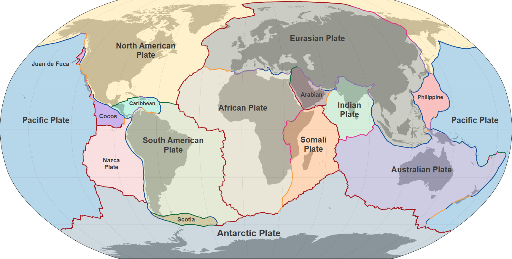
Although there is no consensus among geologists and other researchers in the field, it is believed that at some point 4–2.5 billion years ago, tectonic plates appeared on Earth1. Tectonic plates are fragments of the lithosphere that move over the Earth's mantle. These displacements lead to interactions between the plates that cause the creation and disappearance of part of the Earth's crust, as well as the creation, collision, division, and disappearance of continents.
.svg)
As a result of these erratic displacements, on multiple occasions throughout the Earth's history, all the emerged lands have managed to come together into a single supercontinent, as was the best-known of them all, Pangaea.
Today, we will have a look at some of those supercontinents that have been postulated to exist, as well as some of those that are probably yet to come.
Pangaea
The shape of the coastlines that divide the Atlantic Ocean is suspiciously similar. It is today, and has been all along human history, but for much of that time we have not had complete maps to enable us to make that observation. After Europeans travelled the coasts of the Americas and began to draw the boundaries of the Atlantic Ocean, it became tempting to speculate. Barely a hundred years after Christopher Columbus set foot on the shores of Hispaniola, in 1596, Abraham Ortelius became the first to put this hypothesis in writing2.

According to Ortelius himself in the third edition of Thesaurus Geographicus, a dictionary of classical place-names, Plato had already described the separation of the continents in antiquity. There is no evidence that Plato said such a thing, but Ortelius used this statement to justify his interpretation of the world: the coasts of the New World and the Old World seemed to fit together and this could only be explained if America had been separated from Africa and Europe by a succession of earthquakes and floods.
This idea of Ortelius' was somehow buried in the dust of a handful of libraries. There were thinkers like Francis Bacon who admired this similarity between coastlines, but none went as far as Ortelius. At least not until the late 19th century, when geology began to develop its foundations. In 1858, Antonio Snider-Pellegrini hypothesised that the continents would have been connected 300 million years earlier and based his theory on fossil evidence that coincided on both sides of the Atlantic Ocean.

But the one who really began to build the theoretical corpus that would later become plate tectonics was Alfred Wegener. In 1912, he published a paper, Die Entstehung der Kontinente (The Origin of Continents), in which continental drift was described for the first time. Wegener's theory was that the continents drifted and that, at an early stage, they were all part of a single supercontinent known as Pangaea3.
This idea, now accepted, was revolutionary at the time and, therefore, totally rejected by the scientific community for almost four decades. This was not frontal denial, but rather Wegener's fundamental problem: he had no proposal to explain how the continents moved. Moreover, Wegener made the big mistake of estimating that the continents moved more than 2.5 metres per year, which was extremely fast4. Fast in geological times, of course.
")
In parallel, many other theories about the origins of the continents and changes in the earth's crust were developed, such as the expansion of the ocean floor, seismology, or volcanology. A bit of all of them served to formulate plate tectonics throughout the 1960s, with the participation of many scientists such as John Tuzo Wilson, Edward Bullard, W. Jason Morgan, Dan McKenzie, Robert Parker or Xavier Le Pichon. Le Pichon was the one who finally formulated the model that would be accepted by the scientific community.
And what about before Pangaea?
We know that Pangaea was formed about 300 million years ago. It is estimated that it was unified for about 100 million years, when it split in two, giving rise to Laurasia and Gondwana, with the ocean of Tethys in between. Writing also about this incredible ocean would be too much for this article, so I recommend you to check what
published about it in this other article.Laurasia and Gondwana also split into multiple continents until they reached the continental distribution we have today.

The formation and division of these supercontinents is described by the supercontinent cycle. According to this model, every 400–500 million years, the Earth's crust reconfigures itself and ends up grouping all the emerged lands together. Continental collision brings the continents together into a single mass, only for rifts to break up and divide the continents again, which will then come together once more. This has been happening repeatedly since plate tectonics began several billion years ago.
This is why numerous supercontinents predating Pangaea have been hypothesised. The data we have is limited, so it is impossible to know for sure the exact shape of these supercontinents, but different models have come to interesting conclusions.
The one before Pangaea was Pannotia. It formed about 650 million years ago and held together for almost 150 million years. Its existence was first described by Ian Dalziel in 1997, as a grouping of the continents around the South Pole.

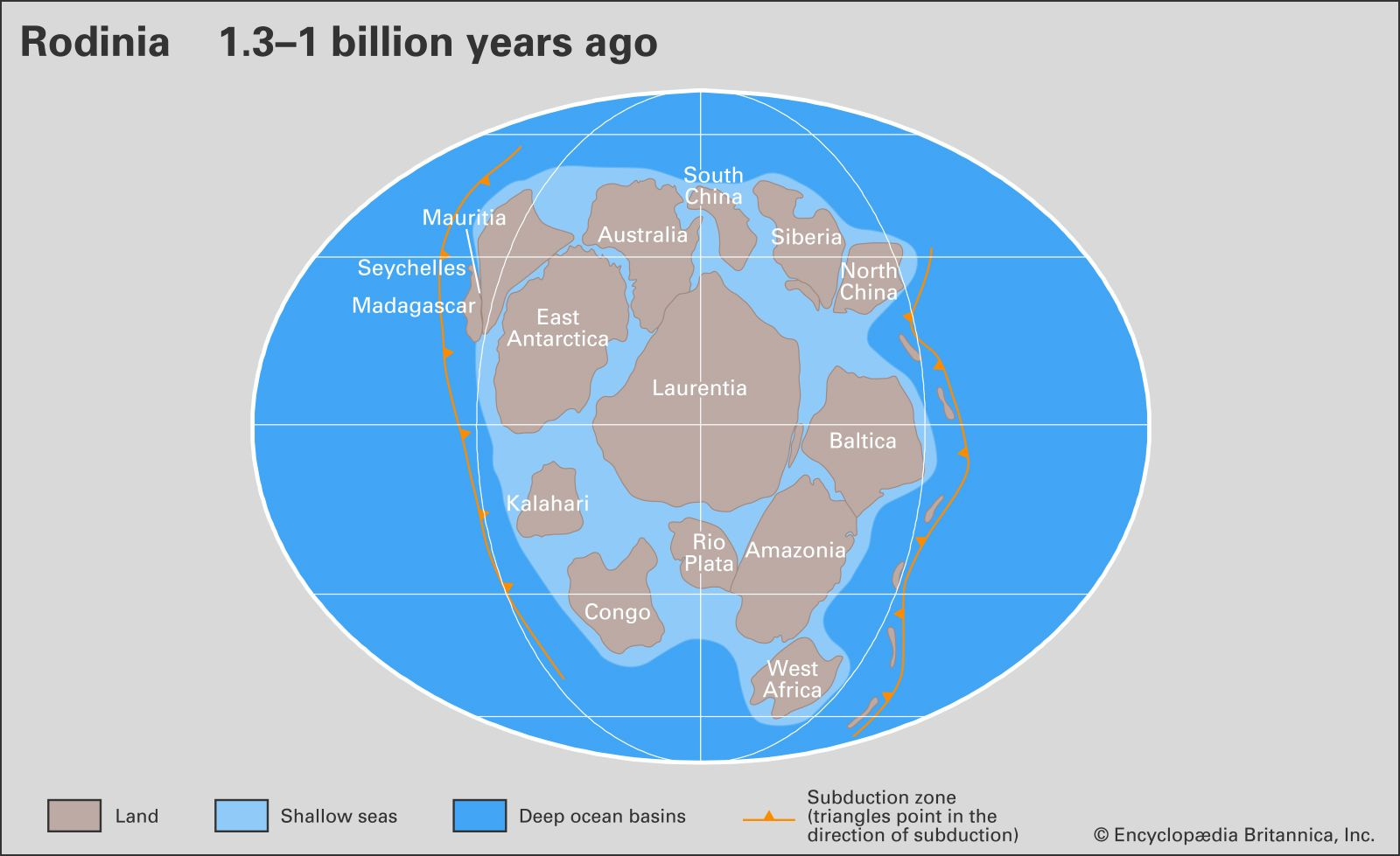
Rodinia was the predecessor of Pannotia. It formed about 1.1 billion years ago and would not begin to fracture until 300 million years later. We know of its existence thanks to palaeomagnetic evidence, which allows us to establish the latitude that the cratons5 had and thus to model how the continents were joined together.
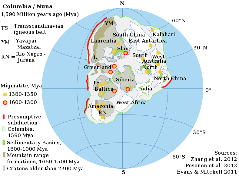
The further we move into the past, the less and less data we have, and the more fragile the reconstructions and hypotheses become. Columbia, also known as Nuna, was a supercontinent that existed about 1.5 billion years ago. As in the case of Rodinia, its existence is based on palaeomagnetic data.
The data from further back hardly provide enough information to be able to establish a hypothesis. The reason is that only two such ancient cratons persist: Kaapvall and Pilbara. This does not rule out the existence of palaeogeologists who have modelled other earlier continents such as Kenorland, Ur or Vaalbara.

What the future holds
Now, let's think that our time is insignificant on a geological scale. As you might guess, we are on the way to another new supercontinent. What's more, if we look closely at the current distribution of the continents, Afro-Eurasia (the grouping of Europe, Asia, and Africa) is already united, accounting for 57% of the emerged land. Researchers have posited three shapes for the next supercontinent that may form.
The first to be postulated was Pangaea Ultima, in 1982, by Christopher Scotese. Because its original name is confusing, as it may infer that it is the last supercontinent, Scotese had to change the name to Pangaea Proxima. According to this model, Africa will collide with Europe and the Mediterranean Sea will close, Australia will collide with Southeast Asia, and the Atlantic and Indian Oceans will disappear. All this will conclude in about 250 million years with this supercontinent.
")
In the late 1990s, Roy Livermore proposed a different model: Novopangaea. The big difference regarding Scotese's model is that it advocates the disappearance of the Pacific Ocean instead of the Atlantic Ocean. Thus, America would collide with the east coast of Asia, Australia, and Antarctica. This hypothesis also stipulates that the supercontinent will form in about 250 million years.

The last model for a future supercontinent is Amasia, which was also suggested in the 1990s by John Baumgardner, but was remodelled in 2012 by Ross Mitchell. This time, as in the case of Novopangaea, the Pacific Ocean would disappear, but with the difference that everything would happen northwards, with all the continents coming together around the North Pole.

We won't be here to confirm which of the three hypotheses is correct. However, all this work in palaeogeology has been key to understanding certain aspects of the evolution of life on Earth, the distribution of species and their adaptation to the environment.
PS: I forgot, but it is very relevant to what I am talking about today. I highly recommend this interactive map that
discovered for me a few months ago. It not only reconstructs the last 750 million years and the distribution of the continents, but you can also search for cities to see where they were located throughout that period. If the land on which they lie today had already been formed, of course.The subject is much more complex than any approximation. The tectonic plates may have emerged early, but it took hundreds of millions of years, or even billions of years, to work the way they work today. Some geologists suggest that plate tectonics as we know it may have been with us for as little as 800 million years.
From the Greek pan- (everything) and Gaia (Earth).
The current estimated speed of the continents is 2.5 centimetres per year, one hundredth of Wegener's estimate.
Cratons, simply defined, are continental masses that have remained rigid and unbroken for hundreds of millions of years.
I had no idea that the previous ‘Pangaeas’ had been named and modelled — makes them feel all the more real!